The World Health Organization on its website has separated the marking of Union territories Jammu and Kashmir and Ladakh from India for the color-coded map revealing the countries affected according to the pandemic numbers, a move that has raised a wave of anger among several Indians.
As per the reports of The Times of India, the global health body has said that it had adhered to all the guidelines given by the United Nations.
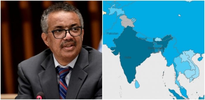
In the color-coded map representation, India is marked with navy blue color, and in contrast Jammu and Kashmir and Ladakh have been shaded with grey color, separating their existence from Indian mainland with color representations. The contentious border based in the Aksai Chin is colored grey with blue stripes, giving similarity to the color representation of Regions based in China.
Nandini Singh, Reach India gives her opinion about UN being ‘in nexus’ with China. She revealed to TOI, “Instead of thanking India for what it has done to fight Covid-19, this is a deliberate attempt to hurt India. WHO needs to apologise to India and correct the error.” Recently, India had conflicts with Pakistan and Nepal based on their display of maps depicting their respective countries. Nepal, in earlier 2020 had publicized a map which showed around 400 sq km inherently in India as its own territory. Likewise, in August 2019, Pakistan’s PM Imran Khan had published a map that enclosed parts of Jammu and Kashmir and Ladakh along with Junagadh based in Gujarat as a part of its territory.